Over 125 attendees joined representatives from the Esri Community Maps team on December 19th to kick off of our new webinar series. The one hour online session included a discussion of the recent Community Maps survey, a demonstration of new data preparation tools and a brief Q&A.
Don Cooke, Product Manager for Community Maps, got things started by providing details on the responses we received to our survey that went live about a month before the webinar. Out of the 109 respondents at the time, over two thirds indicated they were satisfied with the Community Maps Program, while only 11% expressed dissatisfaction. It is good to know that this program is meeting the needs of so many of you, but we will be working hard to improve this number in 2014.
The survey also asked respondents to rank their interest in a list of potential Community Maps Program enhancements, and the results were both helpful and revealing. For the webinar discussion, Don concentrated on the three most popular enhancements.
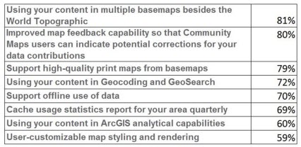
Potential Community Maps enhancements ranked by user interest.
Using contributed content in multiple ArcGIS Online basemaps was the most popular enhancement request, and Don indicated that this will be taking place in early 2014 as our basemaps are refreshed using the Community Maps 2.0 geodatabase containing your authoritative data contributions. The roll out for this will be gradual at first and pick up momentum as we move through the year.
The next most popular request was for improved map feedback capabilities. This is a topic that Don knows well, since he designed and managed feedback mechanisms in his previous job at TeleAtlas. For clarity, he described two different types of user feedback methods – issue reporting and editing. At the present, Esri Community Maps utilizes an issue reporting feedback approach. ArcGIS Online users can submit feedback through our basemap specific feedback web maps. This feedback is evaluated by the ArcGIS Online Content team and referred to the data provider if corrections are necessary.
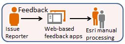
Our goal in the new year will be to move to an editing mechanism that stores user map feedback as a layer in the Community Maps geodatabase. This will allow authoritative contributors to interact directly with the feedback issues (correcting, rejecting or delaying them as necessary) without the intermediate step of going through Esri staff.

The final user enhancement request that Don addressed was for high-quality print support for ArcGIS Online basemaps. This too is a feature that we are working on for 2014, and, like many of the enhancements, will be a benefit of our move from raster map services to vector streaming.
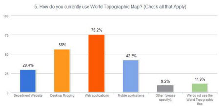
In addition to covering the top three user requested enhancements, Don also shared some other interesting feedback from the survey. One question revealed that respondents used the World Topographic Map (and presumably their contributed content) primarily in web apps and desktop mapping, but that mobile applications were also a significant method of use. It will be interesting to see if this increases dramatically in the coming year.
Respondents were also asked to provide their opinion of an acceptable time frame for publishing content contributed to Esri Community Maps. The most common response (42%) was within four weeks of a data submission, followed by those who thought it should be within two weeks (25%). Don commented that speeding up the entire contribution process is a priority for 2014 and one of the main drivers behind the shift from map caching to vector streaming.
Finally, the survey also tried to gauge the level of adoption for the Local Government Information Model among Community Maps participants. While 35% of respondents indicated that they currently use the model, and many more commented that they intend to adopt it in the future, a sizable majority indicated that they do not currently use the model. Some even commented that this had presented a challenge in contributing data to the Community Maps Program. These results provided a perfect segue into the next webinar topic – new Community Maps data preparation tools that will be released in early 2014.
Seth Sarakaitis, the Community Maps Program Manager, began his presentation by announcing that in early 2014 Esri Community Maps would be adding a new data submission method aimed at simplifying the contribution process for Community Maps participants who choose not to use the Local Government Information Model. This method focuses on the contributor’s input data, rather than a large data model and requires just the features and attributes that are necessary for symbology and labeling.
Most interesting of all, Seth demonstrated a prototype example of new tools that the Community Maps team is creating to help program participants easily prepare their data for submission. In the demo, Seth added a shapefile of building footprints to ArcMap. He then opened a pre-configured tool that allowed him to select the buildings by type, and load them into a ready-to-submit geodatabase. Because of the user-added queries, the output building features had the attribute values necessary to symbolize them by their type (commercial, residential, medical, etc.). The tools are still in development, and will be tested by Community Maps participants before their general release in Q1, 2014, but we are excited about the potential for these changes to decrease the level of effort it takes to prepare data for Community Maps contribution.
As you can see, there was a wealth of interesting and helpful information shared at the first Community Maps webinar. If you missed this one, make sure you attend our next installment at 11:00 am PST on January 16th. In this one ArcGIS Content Product Lead Christophe Charpentier will describe Esri’s new Content landscape, and Community Maps Training Coordinator Mark Stewart will demonstrate how you can make your contributions stand out with special areas of interest. Click here to add this webinar to your calendar.